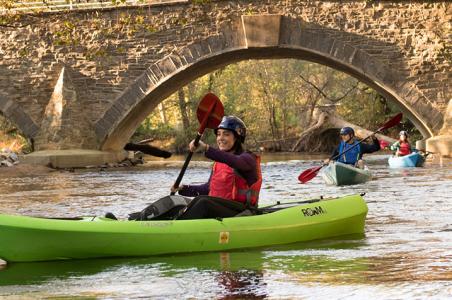

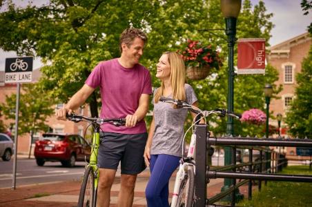
request our
VISITORS GUIDE
 Starting Location: South Middleton Township Park, Boiling Springs, PA
Distance: 38.9 mi
Elevation: + 1334 / - 1335 ft
Description: Mostly pleasant back roads with possible stops in Boiling Springs, Carlisle and Mt. Holly Springs. Stop for a cup of joe or smoothie at Caffe 101 and enjoy it lakeside at Children's Lake. About halfway through your journey take a rest at one of downtown Carlisle's 30+ eateries.
More info: Cue Sheets and Map
 Starting Location: Camp Hill Borough Hall, Camp Hill, PA
Distance: 17.1 mi
Elevation: + 526 / - 525 ft
Description: Explore the small towns of Camp Hill and New Cumberland. You'll find unique shops, places to eat and pass through two parks. This route is along residential and busy connecting roads.
More info: Cue Sheets and Map
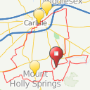
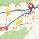
 Starting Location: Carlisle, PA
Distance: 17.8 mi
Elevation: + 354 / - 530 ft
Description: This ride is designed as a through route to Harrisburg. There is no parking at the starting location. You'll be mostly on Route 641, which is a busy road with wide shoulders. There are plenty of places to stop for food, drinks and restrooms.
More info: Cue Sheets and Map
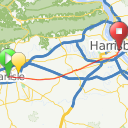
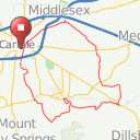
 Starting Location: LeTort Park, Carlisle, PA
Distance: 23.8 mi
Elevation: + 1057 / - 1057 ft
Description: Journey along mostly back roads with beautiful scenery and good climbs. Some portions of this route go through busy sections of Carlisle. Take a snack or lunch and enjoy the serenity and views of Opossum Lake. If you are looking for a longer route add it to the quarter-century and half-century to make a full century.
More info: Cue Sheets and Map
Starting Location: LeTort Park, Carlisle, PA
Distance: 25.9 mi
Elevation: + 860 / - 860 ft
Description: This ride is very scenic with a few gradual hills. Be sure to stop by the quaint village of Boiling Springs and enjoy Children's Lake, learn about and/or hike a little of the Appalachian Trail, grab a bite to eat, or pick up a gift at The Village Artisans Gallery.
More info: Cue Sheets and Map

Starting Location: LeTort Park, Carlisle, PA
Distance: 31.1 mi
Elevation: +971 / - 971 ft
Description: Experience history, village charm and agriculture on this scenic, low-traffic route with a few gradual hills, but mostly gentle terrain. Stop in Boiling Springs for a snack and snap some pictures of the beautiful Children's Lake. In Carlisle, learn about the strength of our U.S. Army soldiers through their personal stories at the U.S. Army Heritage and Education Center. Stop at Oak Grove Farms for some yummy homemade bread and jelly.
More info: Cue Sheets and Map
Starting Location: LeTort Park, Carlisle, PA
Distance: 50.8 mi
Elevation: + 1648 / - 1649 ft
Description: This route is very scenic with a lot of creek riding and sure to be a favorite. Be sure to bring your camera and take a picture at Laughlin Mill and at Huntsdale State Fish Hatchery. Stop at Kings Gap General store for a true general store experience. Pick up lunch before or after a 4-mile gradual climb up to Kings Gap Environmental Education Center and a fun 4-mile downhill ride. At the top of the mountain is a stunning view of the Valley from the porch of the historic Italian villa-style mansion. For a longer ride combine with other Carlisle loops.
More info: Cue Sheets and Map

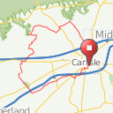
Starting Location: Carlisle, PA
Distance: 23.0 mi
Elevation: + 789 / - 593 ft
Description: About half of this route is along Ritner Highway, which is busy but has wide shoulders and the other portion is along back roads. This route is designed to bike through Carlisle and can be connected with routes from Mechanicsburg and Camp Hill. There is no recommended parking location - Carlisle has metered parking or parking at the Pomfret Street Garage. Directions can be reversed using Ride With GPS.
More info: Cue Sheets and Map

Starting Location: Thornwald Park, Carlisle, PA
Distance: 26.2 mi
Elevation: + 1043 / - 843 ft
Description: This route is mostly back roads or roads with wide shoulders. Stop at the Huntsdale State Fish Hatchery to tour their operation and learn about trout production. Reverse the route using Ride With GPS.
More info: Cue Sheets and Map

Starting Location:Thornwald Park, Carlisle, PA
Distance: 27.7 mi
Elevation: + 1021 / - 821 ft
Description: Looking for a little quiet time? This route is almost all quiet back roads with a stop at Saylors Market in the borough. Enjoy a short scenic ride following Big Spring Creek. To get back to Carlisle reverse the route using Ride with GPS edit function.
More info: Cue Sheets and Map

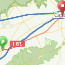
Starting Location: Shippensburg, PA
Distance: 9.6
Elevation: + 76 / - 207 ft
Description: The Cumberland Valley Rail Trail is a crushed limestone trail suitable for most types of bicycles. The trail travels through scenic farmland and wooded areas. Cyclists can enjoy agricultural and Civil War interpretative signage along the way. Bring a picnic lunch to take advantage of picnic tables throughout the trail. There are also restrooms and water at each end of the trail as well as food and other attractions in both Newville and Shippensburg.
More info: Cue Sheets and Map

Starting Location: Newville, PA
Distance: 9.5
Elevation: + 196 / - 70 ft
Description: The Cumberland Valley Rail Trail is a crushed limestone trail suitable for most types of bicycles. The trail travels through scenic farmland and wooded areas. Cyclists can enjoy agricultural and Civil War interpretative signage along the way. Bring a picnic lunch to take advantage of picnic tables throughout the trail. There are also restrooms and water at each end of the trail as well as food and other attractions in both Newville and Shippensburg.
More info: Cue Sheets and Map

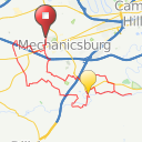
Starting Location: Friendship Park, Mechanicsburg, PA
Distance: 24.2 mi
Elevation: +731/ - 733 ft
Description: Enjoy a leisurely ride through mostly gentle terrain on low traffic rural roads. Your trip will take you through the picturesque village of Boiling Springs, which is recognized as an official Appalachian Trail Community. Enjoy the beauty and serenity of Children's Lake. Stop at Oak Grove Farms in Mechanicsburg for fresh fruit, vegetables, and homemade baked goods and jams.
More info: Cue Sheets and Map
Starting Location: Pleasant View Park, Mechanicsburg, PA
Distance: 28.2 mi
Elevation: + 1216 / - 1216 ft
Description: Cycle through mostly quiet, scenic back roads with some good climbs. The highlight of this route is the picturesque Yellow Breeches Creek, which is world renowned for fly fishing due to the crystal clear limestone waters. You'll also pass through the beautiful campus of Messiah College.
More info: Cue Sheets and Map

Starting Location: Pleasant View Park, Mechanicsburg, PA
Distance: 32.5 mi
Elevation: +989/ - 988 ft
Description: Enjoy a leisurely ride through mostly gentle terrain on low traffic rural roads. Your trip will take you through the picturesque village of Boiling Springs, which is recognized as an official Appalachian Trail Community. Enjoy the beauty and serenity of Children's Lake.
More info: Cue Sheets and Map

Starting Location: Pleasant View Park, Mechanicsburg, PA
Distance: 33.6 mi
Elevation: +1274 / - 1278 ft
Description: A meandering route through quiet roads with scenic mountain and creek views. Stop at Willow Mill Park to see the impressive Veterans Memorial and Oak Grove Farms' Country Farm Store. Depending on the time of year you can pick select fruit, veggies or flowers.
More info: Cue Sheets and Map
Starting Location: Shippensburg, PA
Distance: 20.8
Elevation: + 733 / - 920 ft
Description: There are no public parking areas near the start or finish locations, as this route is designed for through travellers. The route is along busy roads, mostly with wide shoulders. There are places to stop at the beginning and end of your journey for food or restrooms. Route can be reversed using Ride with GPS edit function.
More info: Cue Sheets and Map