request our
VISITORS GUIDE


The Conodoguinet Creek is approximately 90 miles long and weaves through agricultural lands, villages, and small towns. You can enjoy a leisurely float, fishing, bird watching, and even turtle hunting (view our turtle hunting video) on this Class 1 stream. The trail begins near Carlisle at North Middleton Park. Its series of elaborate bends and loops meander through Cumberland Valley and end at "The Point" in West Fairview, where the creek flows into the Susquehanna River. “Conodoguinet” comes from an Indian word meaning “a long way with many bends.”
The Conodoguinet Creek Water Trail Guide and Map (.pdf) provides park and recreation information for approximately 40 miles of the creek. This guide outlines two float trips: one short route (Trip A) west of the Carlisle Dam and a second extended route (Trip B) east of the Carlisle Dam. There is no public portage at the Carlisle Dam. Do not attempt to navigate over the dam! See trip ideas below.
A Long Way with Many Bends is an online interactive map and video that visually tells the story of the Conodoguinet Creek and Watershed, the Conodoguinet Creek Water Trail, and the Conodoguinet Creek Watershed Association. Click here to learn more about the geology and agriculture of the creek and hear about efforts to protect, preserve, and promote the watershed. The Center for Land Use and Sustainability at Shippensburg University and the Conodoguinet Creek Watershed Association produced the project.
Access to the creek for fishing and boating is available 24 hours a day with the following stipulations:
The Conodoguinet Creek offers a variety of recreational opportunities, including:
Birding: Be on the lookout for herons, kingfishers, osprey, and eagles.
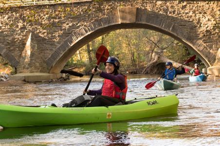
Canoeing/Kayaking/Tubing: As a Class 1 stream, the Conodoguinet is characterized by easy-moving water with a few riffles and small waves, suitable for a beginner. The best stream flow conditions generally occur between November and April. The Conodoguinet is usually canoeable throughout March and April and into mid-May. However, stream conditions may remain favorable in a wet year through July.
Fishing: From Shippensburg to Mechanicsburg, the creek is fed by numerous limestone steams, most notably Big Spring Creek and Letort Spring Run. The section from Carlisle to the Susquehanna River near Wormleysburg is popular for both fishing and boating. There are a wide variety of fish species, but smallmouth bass, rock bass, and sunfish are the most common gamefish found in the Creek between Carlisle and Harrisburg. The Pennsylvania Fish & Boat Commission also stocks tiger muskellunge fingerlings in the creek. (Note: When fishing with bow and arrow, compound bows, crossbows, spears, and gigs, please do not shine spotlights, mounted headlights, or other artificial light from any watercraft upon any occupied building or another watercraft or make generator noise that exceeds the PA Fish & Boat Commission standards. A proposed amendment to make these actions illegal under the Commission's regulations was put forth in March 2022 and is expected to be approved shortly.) During peak summer season, anglers should go fishing mid-week or early morning to avoid kayakers, swimmers, and those on inner tubes.
View details about Trip A & B and access points in the above downloadable guide or by clicking on each park.
Trip A
A1- North Middleton Park
A2 - Cave Hill Nature Center (take-out only)
Trip B
From the Creekview Park access point, you can float for over 36 miles without having to get out (depending on any natural impediments such as downed trees or water levels). The first 30 miles have eight access points as they wind through private woodlands and away from roads. The last six miles have eight access points as well, but they are in a more densely populated section bordering residential neighborhoods. (Credit: Information provided by Pennsylvania Angler & Boater, July/August 2020, www.fishandboat.com)
B1 - Creekview Park
B2 - LeTort Falls Park
B3 - Scott Farm Appalachian Trail Work Center
B4 - Willow Mill Park
B5 - Hidden Creek Park
B6 - Westover Commons Area
B7 - Good Hope Access
B8 - Conodoguinet Youth Park
B9 - Acri Meadow Park
B10 - Oyster Mill Park
B11 - Adams-Ricci Community Park
B12 - Siebert Park
B13 - Pine Hill Arboretum
B14 - Ridley Park
B15 - Rupley Park
B16 - West Fairview Park
B17 - West Fairview Point (take-out only)
Be sure to check stream conditions and real-time water levels before embarking on a float trip.

